
Figure 1. Location of the "cauldrons". Note also the progression north of the quakes over time, as the dyke extended. (Ice News)
The migration has also reached the Askja volcano, which might be a second path for the magma to reach the surface.
Erik Klemetti has written about the different scenarios that might happen should the magma reach that point, with there being some risk of an Eyjafjallajökull type eruption as one of five possible scenarios for the region.
As with the previous post on this activity, I will update below the fold for future developments.
UPDATE: 29th August.(There is a second under the fold(.
An eruption has begun in the northern end of the dyke. Because it is neither in the Askja caldera, nor under the ice, there is little ash cloud at the moment. According to the Ice News report:
Shortly after midnight a fissure eruption started between Dyngjujokull glacier and the Askja caldera in the Northern region of lava field Holuhraun. It is a fissure eruption on what appears to be a 300 metres long rift with a NA-SE direction. No volcanic ash has been detected with the radar system at the moment. The wind field conditions in the area are wind blowing toward NW at 12 m/s at 5 km altitude. Seismic eruption tremor is low indicating effusive eruption without significant explosive activity.UPDATE #3: Here is a picture showing the outflow of magma, from Reuters via The Daily Mail.
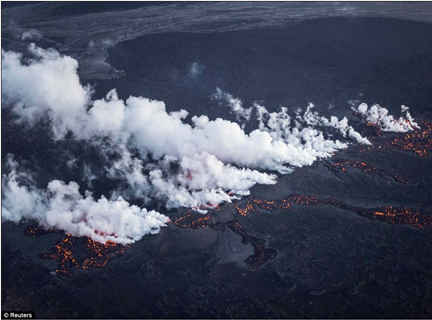
Figure 1a, Magma flow out along the fissure.
2nd update on 29th August.
Watching the eruption on the on-site cameras, the Bárðarbunga 2 camera appears to be continuously shaken by earthquakes at 10:52 am Eastern, and the map of the quakes shows strong activity back at the Bárðarbunga caldera. It really depends on where the initial magma entry is into the dyke, which is most likely to be back at the south end of the dyke. This would increase the risk of at least some of the magma breaking through the ice cap and projecting an ice cloud.

Figure 2. Earthquake pattern on the morning of the 29th. (Icelandic Met Office via Wattsupwiththat).


No comments:
Post a Comment