Showing posts with label Iceland volcano. Show all posts

Friday, October 31, 2014

Tech Talk - more on volcanoes, peak oil and slow transitions

Many news agencies are following the slow inundation of the Hawaiian town of Pahoa, as lava from Kilauea inches into the small town at the rate of around 15 ft an hour. It is a slow death to parts of the community since the lava started moving in June and the flow has travelled over 24 miles on its way to the sea. Not quite as prominent in the news is the continued outflowing of lava in Iceland where the flow from Bárðarbunga has now covered just over 25 square miles, and the threat from the outpouring of sulfur dioxide continues to move around the island as the wind patterns change. As the energy of the eruption falls, there is concern that less of this is getting into the upper atmosphere, causing higher concentrations in the lower layers of the cloud. The volcano is putting out about 35,000 tonnes a day more than all the industries in Europe. Safe concentrations are considered to be around 500micrograms/cu. m. while levels as high as 21,000 micrograms have been measured.


Figure 1. Gas cloud threat from Bárðarbunga on October 31 (Icelandic Met Office)

It is only the high winds of the Icelandic winter that dilute the gas below the threat to individuals. And yet the earthquakes in the caldera persist with events above level 5 still occurring almost daily. There were 200 yesterday, with ten being larger than magnitude 4.


Figure 2. Earthquakes in the Bárðarbunga region of Iceland in the last 48 hours. (Icelandic Met Office)

The water in the caldera is melting at an estimated rate of 2 cu. m/second with hot magma residing under the originally half-mile thick glacial cap.

While these events are generating hundreds of megawatts it is not in the form of useful energy at this point, but despite the disappearance from the headlines of the Icelandic event, it still has the potential for much greater societal impact than does that in Hawaii. But it will happen more slowly (at least until the potential eruption when the icecap is penetrated.) And sadly it is this demonstration of the short-term focus of the news media and the need for dramatic pictures that again bring me to the analogy of these events to what is happening with Peak Oil.

As noted in an earlier post, the EIA have pointed out that the current glut in oil availability and thus the fall in gas prices correlates inversely with the increase in production from Libya. Their OPEC governor has pointed out that the current global oversupply is at around 1 million barrels a day. Libya has recently produced about 800 kbd of this, and while OPEC as a whole is not worried out the imbalance (since they are projecting that global demand will rise this much over the next year), he would like to see current production curtailed by 500 kbd to get the price back over $100 a barrel.

It is this marginal supply of around half-a-million barrels a day which is now the level of volume that can transform us from having too much to not enough. Which goes back to the remarks that Charles Dickens put in the mouth of Mr. McCawber:
'My other piece of advice, Copperfield,' said Mr. Micawber, 'you know. Annual income twenty pounds, annual expenditure nineteen nineteen and six, result happiness. Annual income twenty pounds, annual expenditure twenty pounds ought and six, result misery. The blossom is blighted, the leaf is withered, the god of day goes down upon the dreary scene, and - and in short you are for ever floored. As I am!'.
Our sixpence, it would appear, is now at around that 500 kbd. OPEC will not increase production much above current levels, in fact it is hard to see where they could anticipate being able to do so. Libya remains threatened by worsening violence, which has been approaching the El Sharara oilfield and it remains questionable as to whether they can continue to sustain production.

The other big question mark remains Iraq. How far the Kurds can increase production up through the pipeline to Turkey remains a question. They have recently announced that the new pipeline is carrying 240 kbd and if the logistics can be put in place the volume could well increase. Problems however with contractors, making the necessary field connections and the nearby conflict will likely combine to slow that progress.

If both sources of supply continue to produce, and even increase a little more than at current levels then the global surplus will still be eaten up by increased demand over the next year. The short-term drop in prices (which may well extend over the winter) will gradually disappear as the surplus reduces. And in so far as the current drop in prices discourages new investment in costly alternate places, even if only in the short term, that cannot but help OPEC as supplies tighten in the future, and that competitive oil is not in place in the market to reduce the consequent price increase.

The short-term loss therefore may well, before long, be returned in higher prices in the summer and towards the end of next year. Such a projection assumes that the recent increases in US production will slow down, and that seems to be a reasonable assumption, given the changing price structure and the lower returns on wells drilled outside the “sweet counties.” One can only drill so many wells where production is rewarding, before the land gets full.

In the short term the drop in prices will also encourage demand, helping to build back what had been a falling away from earlier OPEC projections of demand growth. It will be an interesting year, and perhaps one that will change faster than the slow but steady changes that the volcanoes are having on their local communities. But if so it may still be too slow for the media to closely follow, since many of the controlling events take place away from media attention and occur without, often, immediate visible impact.

Read more!

Friday, September 12, 2014

Iceland livens up

Jón Frímann points to an interesting pattern of earthquakes around the caldera at Bardarbunga, suggesting that the volcano might be getting ready to erupt.

Icelandic Met Office.

It is hard to tell from the webcams, since Bardarbunga 2 is shaking too much. This may be bad weather - except that the weather shown at the first camera shows that it is clear on the left, suggesting that there is a lot more ash being thrown into the air. So this may be a more significant eruption already, due to the ash cloud.

Bardarbunga web cam at 10:43 am 12th Sept.

UPDATE: The increasing concern comes from the clouds of SO2 that are being emitted from the craters. This poses threats, not only to those in Iceland, but also potentially to some in Northern Europe. The smell of sulphur is now being detected in Norway. The latest path for the gases has been posted:


Figure 3. Path of the gas cloud from Iceland.(RUV )

The Icelandic Met Office is now issuing bulletins in English as well as Icelandic.

More later.

Read more!

Sunday, August 31, 2014

Global oil supply and Bárðarbunga

Some time ago magma started rising in the rocks near the Bárðarbunga volcano in Iceland, and after weeks of increasingly intensified earthquake activity, the first signs of eruption were found to have occurred under thick ice within the last week. These were not that visible to the general public. That eruption was followed by a second, where there were some streamers of magma across the surface, without causing any significant airborne dust to interfere with aircraft.

The delays in dramatic eruption footage, and the early decay in immediate activity has led a number of folk to anticipate that the risk has declined and for some the risks from the eruption are over, with one scientist commenting::
"If this eruption persists it could become a tourist attraction, as it will be relatively safe to approach, although the area is remote,"

Figure 1. The eruption at Bárðarbunga (from the first webcam) at 5:40 pm Aug 31.


Figure 2. The eruption at Bárðarbunga (from the second webcam) at 9:00 pm Aug 31.


The eruption is continuing and will likely continue, and potentially significantly worsen, over the next several months. Yet, in the world of instant highlights, headlines and Twitter the risks from the long-term eruption (which can be horrendously severe) are immediately glossed over as the eruption fails the “dramatic event” test.

This is uncomfortably similar to the situation that one sees when writing about “Peak Oil”. One can, on any individual day, find comforting headlines that tend to gloss over the longer-term problem that is being written, in increasingly large letters on the predictive wall of our future. But that does not hide the potential disaster that it presages, it merely conceals it from the general public.

The headlines are those that are short-term, and deal with the drivers for the daily fluctuations in oil price, rarely do they back off to look at the overall threat that the situation may presage. Similarly the eruption in Iceland looks relatively tranquil at the moment, but may be of a similar nature to that of 1783, which created, over a period of months, an absolute disaster in Europe, and may have been one of the contributing causes to the French Revolution. The problem with the oil crisis is that there is no similar history to look back on. (Not that this would matter to those “editors of the moment” who control the daily press).

If one were to step back from concerns over daily price fluctuations for oil and gasoline, and consider the import of the trend in international politics one could very easily be aghast at the situation. Not that one might tell this from the headlines.

Consider that, of the three international leaders in oil production, one – Russia – is currently set on a course that may well lead the rest of us into World War 3. As a consequence is likely to be unable to attract the financing that will allow it to even approach the current levels of oil production that it need to retain current production levels in the years to come.

The second of the three is Saudi Arabia. Glossing over any problems that the Kingdom may run into in the next couple of years with the terrorism that is sweeping though its neighbors, it is a country that has realized that today’s cornucopia is about over, and it must seriously invest in exploration and development. The KSA recognizes that if it is to have a chance at being able to even meet the bills for domestic consumption, let alone export income, as the years move onward, it must find new oil. Again it would seem that global commentators fail to realize that, while KSA is recognizing the problem, any finds of “elephantine fields” would require huge investments of money and time, given that they are now likely to be off-shore and sour (as with Safaniya and Manifa, even if such fields exist, which is very doubtful).

The Kingdom has repeatedly stated that it will not increase its production over current levels, despite the assumption of many commentators that they will have to, if global balance is to be retained between supply and demand. Put bluntly, their analysts have realized that, without new reserves that are currently still to be found, they will be unlikely to be able to meet even current targets without major new field finds. Yes, they have fields that are found and available, but in relative terms they are tiny when set against the current levels of production. (Bearing in mind that a 5% reduction in production per year from existing fields, a level now increasingly found to be overly optimistic, would still cut existing production by 450 kbd).

And so, gentle readers, as we have so often in the past, we return to prognostications of future American production. This should, realistically, be focused on the production from the USA, since that in Canada is tied to production from the oil sands and that is only likely to change at a slow (one might suggest geological, but that would be a little harsh) time frame.

And in the United States hope continues to focus on an assumed linear increase in production, month on month, from the Bakken and Eagle Ford Shales. That this is denied by even the local authorities (who also note that the Bakken is named after a local farming family). Their current estimate (assuming more than 200 drilling rigs, and there are currently only 192 is that the fields will peak in 2017, and will start to decline in around 2026. The problem with that estimate relates both to the number of rigs employed (which have to be higher) and the quality of the remaining reserve (which is highly unlikely to be of equivalent value to that which is now, or has been, developed in the past.

I would venture into the second tier producers, but they include those that lie in the MENA (such as Iraq and Libya) and are in even worse condition than KSA, and yet, as documented here repeatedly, these states seem increasingly unlikely to meet projections and thus are an ongoing and significant threat to a balance between global production and demand.

The global economy, and particularly the economies of the Western countries, are tied to a cheap source of energy and power – on which their industrial clout is based. Remove that underpinning, and the writing is clear on the wall about this, and current levels cannot be sustained.

But, as with the wish of the press to get “beyond” the “yesterday’s story" of Bárðarbunga, so the reality of the energy situation is unlikely to be recognized until, as with the Iceland volcano. its effects become too evident to ignore.

Read more!

Thursday, August 28, 2014

Iceland volcanic eruption may be under the ice

The BBC are reporting that small "cauldrons" have appeared on the glacier over the growing dyke of rock that is penetrating upwards in the Bárðarbunga region of Iceland. This suggests that the magma has reached the bottom of the ice, and causing it to melt, with the overlying cap then collapsing into the cavity. Jón Frímann notes that the water in Grímsvötn Lake has risen about 15 m, so that presumably is where it is flowing at the moment. That rise is equivalent to the melting of around 45 million cubic meters.


Figure 1. Location of the "cauldrons". Note also the progression north of the quakes over time, as the dyke extended. (Ice News)

The migration has also reached the Askja volcano, which might be a second path for the magma to reach the surface.

Erik Klemetti has written about the different scenarios that might happen should the magma reach that point, with there being some risk of an Eyjafjallajökull type eruption as one of five possible scenarios for the region.

As with the previous post on this activity, I will update below the fold for future developments.

UPDATE: 29th August.(There is a second under the fold(.
An eruption has begun in the northern end of the dyke. Because it is neither in the Askja caldera, nor under the ice, there is little ash cloud at the moment. According to the Ice News report:
Shortly after midnight a fissure eruption started between Dyngjujokull glacier and the Askja caldera in the Northern region of lava field Holuhraun. It is a fissure eruption on what appears to be a 300 metres long rift with a NA-SE direction. No volcanic ash has been detected with the radar system at the moment. The wind field conditions in the area are wind blowing toward NW at 12 m/s at 5 km altitude. Seismic eruption tremor is low indicating effusive eruption without significant explosive activity.
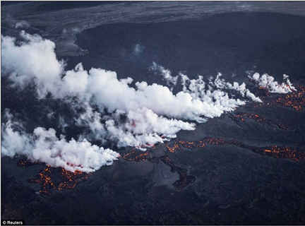
UPDATE #3: Here is a picture showing the outflow of magma, from Reuters via The Daily Mail.


Figure 1a, Magma flow out along the fissure.

2nd update on 29th August.
Watching the eruption on the on-site cameras, the Bárðarbunga 2 camera appears to be continuously shaken by earthquakes at 10:52 am Eastern, and the map of the quakes shows strong activity back at the Bárðarbunga caldera. It really depends on where the initial magma entry is into the dyke, which is most likely to be back at the south end of the dyke. This would increase the risk of at least some of the magma breaking through the ice cap and projecting an ice cloud.


Figure 2. Earthquake pattern on the morning of the 29th. (Icelandic Met Office via Wattsupwiththat).

Read more!

Saturday, August 23, 2014

A small eruption, so far (but the threat is getting bigger)

Jón Frímann is reporting that the eruption has started, but as yet is small. There are some web cameras and in the comments on his post there is some discussion of what they show, with the picture below showing what appears to be the start of a fissure eruption. This is consistent with an intrusion of the magma in the form of a dyke which is traceable from the earthquake patterns.


Figure 1. Webcam view of the start of the Bárðarbunga volcanic eruption.

The activity seems to be occurring in several places, with that part that is under the ice not being visible, were it be occurring, though if it breaks through the ice then this is where the larger plumes might be generated.

Figure 2.Earthquakes around the site (Icelandic Met Office)

The condition has been changed to RED, with the Met Office reporting that there are 150 to 400 m of ice above the surface in the region of maximum activity, and it will take some time for the magma to burn through this to the point where it ruptures, if it is big enough to do so. However the latest earthquakes include one of over 4.5 which is quite a bit bigger than earlier ones.

This has been UPDATED on 24 August

And on August 25th.

And on August 27th, as the quakes continue and approach the surface

.

The activity is continuing to grow.


Figure 3. Later on the 23rd. (Icelandic Met Office via Jón Frímann)

The eruption is definitely occurring along a rift in the rock. The development can be seen from a picture of the developing earthquakes from the 16th August, as Jón Frímann shows.


Figure 4. Development of the eruption as the magma moves along a rift to form a new dyke which is rising to the surface, prior to the eruption on the 16th August (Icelandic Met Office via Jón Frímann)

The growing size of the potential eruption can be seen from the latest picture of the earthquake activity, with it spreading away from the caldera.


Figure 5. Overview of Iceland showing the increasing scope of the activity on 24 Aug. (Icelandic Met Office)

The dyke is reported to be 40 km long already, and the magma, outside the ice cap may likely flow without much of it generating the high clouds of ash that are a threat to aircraft, and future weather patterns in Europe. (These eruptions can last some time). However if the bit under the icecap breaks through then the combination of water turning to steam and thermal shock on the rock can generate the very small particles which become a threat to both.

25th August Most of the activity is still occurring about 5 km below the surface, and the question becomes where, if anywhere, will the eruption reach the surface.


Figure 6. Earthquake activity 25th August 2014 (Icelandic Met Office).

The latest quake above magnitude 3.0 is at the northern end of the activity, suggesting that perhaps the magma is flowing in that direction, so that if it were to migrate to the surface then it would not come out under the ice cap. Which would be good news from the viewpoint that it is less likely that this will generate the high clouds of micro particles that might have occurred, as they did with the Eyjafyallajokul eruption in 2010.


There is, however, another concern that comes from the basaltic flows of lava, and was at its likely worst in 1783 when the nearby rift at Laki opened. The gases produced are toxic and were of sufficient volume that a large portion of the livestock and crops died, leading to the death of a quarter of the population from famine. The impact on Europe was also severe, with some suggesting it as a partial cause of the French Revolution. In part this was because of the resulting haze (which spread globally)which dropped temperatures around the world.

It also lasted eight months.

August 27th - The activity continues with quakes above 3.0 along the dyke, and with the earthquakes seeming to be approaching the surface.


Figure 7. Earthquke activity 27th August 2014 (Icelandic Met Office)

Read more!

Sunday, August 17, 2014

Iceland may soon have a new volcano

Most of my focus as I watch the earthquake patterns in Iceland has been on the Mýrdalsjökull glacier, but it appears that the number of quakes up at Bárðarbunga has reached the point of concern.


Earthquake pattern in Iceland on Aug 17, 2014 (Iceland Met Office)

A closer look at the site seems to show that the activity is due to magma movement, and there is an ongoing ground swelling which supports this.


Closer look at the eruption pattern (Iceland Met Office)

Jón Frímann has been watching the site and has a more detailed description of what the instruments are showing. Note that the activity is under the ice cap, so if it breaks through this may well contribute to the size of the particles generated, and the resulting size and path of the debris cloud.

I will update below the fold if this situation gets worse.
UPDATED Aug 18th, twice since the Icelandic Met Office have now raised the warning to orange. (h/t Jón Frímann)

One day later and, depending on your point of view, the quakes are getting more focussed, or the activity is beginning to settle down. The stars denote quakes that are larger than 3.0, though these two barely make that distinction, and there is one around each of the foci of activity.


Figure 3. Earthquake activity August 18, 2014 (Iceland Met Office)

UPDATE 2 at 4:30 pm

As noted above the fold, the Icelandic Met Office has noted the increasing levels of activity and has upped the warning for the region to orange, which means:
ORANGE: Volcano shows heightened or escalating unrest with increased potential of eruption.
This is only superseded by RED, which occurs when either the eruption is imminent or already happening.

Read more!

Tuesday, July 8, 2014

Myrdalsjokull - is Katla getting ready to rumble again?

This is likely, again, not likely to amount to much, but as Jón Frímann has noted, the Katla volcano in Iceland is getting a bit antsy again. There were a couple of deep quakes nearly two weeks ago and there have been shallower and more numerous quakes since.

These might indicate that magma is making its way upwards. We saw this a few months ago, and it did not amount to anything in the end, but it is a little early to tell yet whether this pattern will be the same, or more serious.


Earthquakes in the Myrdalsjokull caldera July 7, 2014 (Icelandic Met Office)

For those who don't know, Katla has often erupted after Eyjafjallajokull, which noticeably erupted back in 2010, shutting down air traffic at the time. And Katla is often the more violent of the two - hence the current interest.

I will update this if it develops into something that may turn out to be more serious.

Read more!

Saturday, May 10, 2014

The Icelandic Earthquakes are a little stronger

There seems to be an increase in the strength of the quakes that are happening along the southern part of the line, initially focussed on the Reykjanes Ridge, but now apparently spreading further north. Although it looks intense, remember the scale over which the events are happening. And also remember that these indicate some movement, so that those parts next to them that don't move will build up stress that must, ultimately, be relieved.


Figure 1. Earthquakes in Iceland in the 48 hours before May 10,2014 (Icelandic Met Office)

There is no more. . . . .yet

Read more!

Friday, April 4, 2014

Iceland becomes a little more active

So I just glanced at the Iceland Earthquake map again tonight, and it has become a little more active than in recent times.


Recent quakes in Iceland (Iceland Met Office)

As a reminder:The colors of the circles show the time since the earthquakes occured (the numbers below the color palette represent hours). The latest earthquakes are shown in red and the dark blue ones occurred over 24 hours ago. The earthquakes stay blue until 48 hours have elapsed since their occurrence, then they disappear. Earthquakes bigger than M3 (on the Richter scale) are represented with green stars that turn yellow after 24 hours.

No more - as yet!

Read more!

Wednesday, March 26, 2014

Watching Iceland

Those of you who have visited this site for a while will know that I have this rather odd curiosity about Icelandic volcanoes, and more specifically the Myrdalsjokull site that sits next to Eyjafjallajokul in southern Iceland. The Icelandic site that monitors earthquakes is one I glance at fairly regularly. It has been an interesting site to visit this winter, since – more than in most years – the island has been relatively quiescent. Except that there has been this fairly consistent activity along the southern part of the rift, running roughly from Reykjavik east to Myrdalsjokull. I bring it up again today just because the sequence of earthquakes has again moved along that fault line and ended at the glacier.

Figure 1. Recent earthquake activity in Iceland (Icelandic Met Office )

Nothing big is happening immediately, just that the whole movement along this southern wing, suggests that, in time, there will be a switch to the north-south element, and at that time the stress on the corner, where we know there has been some magma movement, might prove – as they say – earth shattering!! But this is geological, where time is on a different scale than most of us.

Read more!

Saturday, May 11, 2013

More rumblings in Iceland

At the beginning of April there was a burst of earthquake activity just off the northern coast of Iceland, and while it occurred offshore there was no evident major disruption. Now there has been a similar flurry of activity down along the southwest corner. (Ed note This was corrected on May 13, h/t to Steve Golson for catching the error which had east and west mixed up). This contained a number of quakes that ran up to around 4, but it also now seems to be slowing down a little.


Figure 1. Earthquakes in the last 24 hours around Iceland (Icelandic Met Office )

Jón Frímann has written a post pointing out that the activity seems somewhat cyclic, and that the last significant events were in either the 18th or 19th centuries, with no indications of any imminent danger.

Both the current events and the ones at the top of the island lie on the Mid-Atlantic rift that runs through the island, and marks where two of the earth’s plates are slowly drifting apart.

NOTE: This post was updated on Sunday, May 12th.

Figure 2. Map of Iceland showing major volcanoes (The Times of London)

However, you may note on the earthquake map that there is also a little current activity around Katla, which is the volcano that I have been expecting to be the next to erupt, after the pattern of quakes that has occurred there over the past couple of years.

Over at Volcano Café the suggestion has been made that, instead of Katla, it will be the neighbor Hekla that will go next, since there was sufficient activity there to warrant a warning to the public in March. That has since been withdrawn, after the region returned to quiescence. Yet there continues to be some activity in the Katla caldera.

I must continue to remember that imminent in geologic terms does not necessarily mean this month.


Figure 3. Relative positions of Hekla and Katla (which is under Mydralsjokull) (Icelandic Met Office)

UPDATE (Sunday 12th May). While the overall intensity of the quakes it diminishing, I can't help note that they are now extending along the rift line, and taking a straight shot at Hekla.


Figure 4. Earthquakes in Iceland leading up to noon 12th May 2013 (Icelandic Met Office)

Read more!

Saturday, April 27, 2013

Fixated on Katla

It has been more than a couple of years since I started to write on the potential for an eruption of the volcano at Katla in Iceland, following the eruption of its neighbor at Eyjafjallajokull, and the resulting disruption of air traffic.

One of the reasons that I continue to do so, apart from the historic pattern that Katla often erupts following Eyjafjallajokull, is the ongoing earthquake activity around the caldera. I noticed it clearly again today where with most of the zones of Iceland quiet, there is still that steady pattern. And this activity has persisted at a relatively low, but varying level, across this time. Doesn't say it will happen soon, but does continue to suggest that it is, nevertheless, going to happen. Patience is a good word.


Earthquakes in Iceland in the last 24 hours (Icelandic Met Office) Hopefully there won't be much more news for a while.

Read more!

Tuesday, April 2, 2013

Iceland's quake activity

After a quiet few months, I see that Iceland is seeing a fair number of earthquakes above 3 in a confined region at the North end of the island. (Those are the events marked with green stars).


Figure 1. Earthquakes in Iceland in the last 24 hours (Iceland Met Office)

A closer look shows how linear the different events have been.


Figure 2. More detailed view of the events shown in Figure 1. (Iceland Met Office).
This post was updated late in the day. (see below the fold).

UPDATE 3. By late evening Wednesday the activity was still strong, though perhaps a few less 4's. (map appended).

UPDATE 4. Friday afternoon and the activity seems to be tapering off a little - and as The Earthquake Report notes quake swarms of this type are quite frequent in the region, and usually peter out after a few days or weeks.

UPDATE 1 Well the situation has not yet stabilized, and as I go to bed, some 12 hours later, the quakes are spreading along the fault line to the mainland.

UPDATE 2. The activity is occurring along the Tjörnes Fraction Zone,, and is being followed and described by Jón Frímann over at the Iceland Geology blog.


Figure 3. The situation at 11 pm Tuesday evening (Missouri time)(Iceland Met Office)

And this is the situation at around the same time on Wednesday evening.


Figure 4. Change in the pattern late Wednesday evening (Iceland Met Office)

Read more!

Thursday, September 20, 2012

Iceland rumbles a bit

This is just a quite arrow to point to the number of quakes above a level 3 that have been happening in Iceland over the last few hours.

Earthquakes in Iceland as shown on the 20th September 2012 (Icelandic Met Office). (Stars are for earthquakes over a level 3, and turn yellow, from green, after 24-hours)

Not quite sure what it means, but Jón Frímann has more of a description of what is going on.

There is no more . . . yet!

Read more!

Tuesday, August 21, 2012

Katla twitches

While the earthquakes in the region around Myrdalsjokull have remained concentrated in and around the Katla caldera for some time, they have been relatively small. However I see that one has just crept up above a value of 3. (Barely it is a 3.1). While in itself this is not significant, it continues to suggest that there is activity within the volcano that will, in time, create problems. There has been too little associated activity to suggest that this is, however, anything critical at this stage.


Figure 1. Recent activity at the Katla volcano in Southern Iceland. The star indicates the location of a 3.1 earthquake, and the green shade indicates that it occurred within the last 24-hours. (Icelandic Met Office.)

There is no more.

Read more!

Saturday, June 30, 2012

Katla draws a line

Just another interesting geometric pattern:
 
Figure 1 Earthquakes around Katla in the 24-hours to June 30, 2012 (Icelandic Met Office)
  There is no more. . . . .yet!

Read more!

Wednesday, June 27, 2012

Katla in Iceland keeps on grumbling

It has been some while since I have posted on the happenings around the Katla volcano in Iceland. I still drop by the Icelandic Met Office site to see how the quake patterns are developing, and the region continues to be the focus of earthquakes that consistently focus around the caldera of the volcano. Something is obviously going to happen, but what and when remain somewhat of a mystery. But I was struck by the pattern of quakes over the past 24-hours. Nothing of any great significance – though I wonder why the quakes are forming the circular pattern? We shall see, no doubt.
Figure 1. Pattern of quakes on Mydralsjokull over the 24-hours up to June 27, 2012 (Icelandic Met Office).
  Jón Frímann has noted that there have been several earthquake swarms in the region in recent weeks, though the most recent did not have any harmonic tremors associated with it. But since this could be an indicator of some thermal activity under the ice cap, it may lead to a flood of melt water from the glacier in the near future. No more.

Read more!

Friday, February 24, 2012

Rumblings in Iceland, (Katla sleeps restlessly)

The problem of dealing with Geological time and having events that occur in very short intervals thereof, is that for those of us on a faster life schedule, “almost instantly” can still be a period of years.

That thought has struck me quite frequently as, over the past year, I have watched the earthquakes that are happening around the Myrdalsjokyll glacier in Iceland, with the Katla volcano rumbling beneath it. I first noted how the earthquakes in the region were focusing down into the caldera of the volcano last May. Since then I reported occasionally as the intensity of the underlying earthquakes increased in intensity up to levels above 3.0, and started to align along possible fissures that might lead from the magma chambers up to the surface.

In the end the volcano did not seriously erupt, but nor did the patterns change that much, and I have kept an eye on the region over the months since. It is worth noting that the pattern of quakes continues to focus in the region of Katla, and that while they vary in intensity and frequency (some days there may only be one or two quakes) that they are still ongoing.

Pattern of Earthquakes in Iceland in the last 24-hours (Icelandic Met Office )

If one clicks on the map at the site over the clump of quakes at the bottom (those on the right at the base of the peninsula are caused by water injection from the geothermal program in Iceland) then one gets this picture:

Quakes in the Katla region of Iceland in the last 24-hours (Icelandic Met Office)

This is about as dispersed a pattern as there has been over the last few months in the region. Eyjafjallajokull was the volcano that erupted two years ago, and brought some disruption to Europe. Katla will likely go at a somewhat greater scale, and likely quite soon – in geological time. For those with shorter attention spans it remains hard to tell whether that will be in 6 months, or 6 years. We’ll just have to keep watching.

Read more!

Thursday, December 8, 2011

Still watching Katla

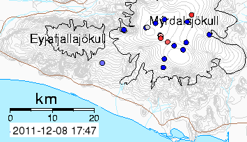
It has been a little while since I wrote about the possible eruption of the Katla volcano in Iceland. For a while it appeared that the increased frequency of earthquakes and their growing magnitude, was leading toward an eruption. Since then the mountain has become somewhat quieter; but the earthquakes remain focused around the caldera, and continue to occur at a higher than background rate. Looking at the pattern over the past 24-hours, there is still a strong linear component to the earthquake pattern, which would tie in the continue evolution of fissures along the edge of the caldera.

Earthquakes around Katla in 24-hours (Icelandic Met Office ).
UPDATED

Jón Frímann does not expect this activity to lead to an imminent eruption, nor do I. But the continued linear nature and focused activity around the caldera is indicative of an ongoing preparation for an eruption. However we are talking about geological events, where time has a somewhat different meaning. Imminence is more likely therefore to be months, rather than days. Yet, as Jon notes, normally winter is a period of quiescence and this year we have not seen that. So I continue to expect an eruption of some significant size, it is just not clear when.

UPDATE
Revisiting the site a day later, there is still a lot of ongoing focused activity, though not yet strong enough to show any immediate large scale activity.


Read more!

Monday, November 14, 2011

The Icelandic volcano at Katla is becoming yet more active

I realize that any claims I have as a prophet have faded as the ash that lies on the Myrdalsjokull glacier from the Eyjafjallajokull eruption last year, failed to be blown away under the summer sun. The underlying volcano, that is Katla, while focusing the earthquake activity in the region has done little more than have a relatively small jokulhlaup (or glacial flood) or two. But I can’t help stirring that old pot at least one more time. Because the earthquake activity at the site remains focused in the caldera, and there has been a recent increase in the frequency with which magnitude 3+ quakes have occurred at the site. I was checking on the one that happened last week, and noticed that there are two new ones since last I looked.

Earthquakes in the last 24 hours around the Katla volcano in Iceland (Icelandic Met Office)

UPDATE: The Icelandic Met Office has another page, which shows the quake map in a different mode, and also gives the frequency over the past day. It currently shows an interesting pattern for the quakes of the last 24 hours.

Earthquakes around Katla in the last 24 hours (Icelandic Met Office ) The line follows that of the perimeter of the caldera (the black hatched line).

Note the site also shows the corrected size of the earthquakes, while the earlier site gives an automated assessment. and, as an update, there are consequent tremors that are falling along the same boundary.

The larger earthquakes are also increasing in size, these two being a 3.8 and then a 3.3, occurring about 3 km apart, which with the intervening activity (the red dots) which included a 2.4 suggests that there just might be a fissure opening. (The now corrected values are given in the lower figure).

Three days ago Jón Frímann noticed signs from his geophones indicating that a new dike had intruded into the caldera. The current activity is a little north of that event, it is also very shallow, with the first and larger quake being at 2.5 km depth while the subsequent ones are down around 1.1 km.

Read more!